湿地是“山水林田湖草”生命共同体的重要组成部分,湿地的保护与管理对于“美丽中国”建设至关重要。20世纪50年代以来,受到气候变化和人类活动的双重胁迫,中国湿地面积大幅减少,空间分布范围明显萎缩。高精度的湿地空间分布信息是国家湿地保护与管理决策支持和湿地科学研究的重大科技需求。
东北地理所王宗明研究团队近年来在湿地遥感研究领域取得一系列进展,主要包括:(1)研发了高精度国家尺度湿地分布数据集CAS_Wetlands、红树林动态数据集CAS_Mangroves、互花米草入侵数据集CAS S. alterniflora、滨海养殖池扩张数据集CAS_Coastal Aquaculture;(2)基于遥感大数据,解析了我国湿地面临的主要威胁,阐明了我国湿地损失与恢复的时空特征;(3)构建湿地水禽栖息地适宜性评价模型、湿地恢复空间决策支持模型,建立湿地保护工程成效遥感评估指标体系和评估方法。相关研究成果发表于ISPRS Journal of Photogrammetry and Remote Sensing、Science of the Total Environment、Journal of Cleaner Production、International Journal of Applied Earth Observation and Geoinformation、Land Degradation and Development、Remote Sensing、Sensors、Biogeosciences、Journal of Environmental Management、Ecological Engineering等国际重要期刊,并被新华网、中国日报、央视网、中国科学报、科学网、新浪网、网易、搜狐网等媒体广泛报道。这些研究由东北地理所王宗明、毛德华、贾明明、任春颖、宋开山、姜明,东北地理所海外特聘研究员美国印第安纳大学李林、美国罗德岛大学王野乔、美国亚利桑那州立大学邬建国,中科院空天信息研究院吴炳方、曾源,中国科学院国家天文台张渊智,武汉大学王超等共同完成。
近期,王宗明研究团队生产的30米分辨率中国湿地空间分布数据集(2015年)在国家地球系统科学数据中心、国家地球系统科学数据中心黑土与湿地分中心、东北地理所科学数据中心公开发布,免费共享,注册后即可下载。研究团队采用集成面向对象方法与多层决策树的湿地分类技术(HOHC),进行国家尺度湿地分类,最终获得2015年中国沼泽湿地、红树林、互花米草、滨海养殖池的空间分布数据集,总体分类精度在92%以上。该数据集可以作为国家落实联合国可持续发展目标SDGs进展状况评估的重要基础,为国家《国际湿地公约》具体履约行动提供关键数据支撑,也可为我国湿地生态系统有效管理与保护、外来入侵物种防治、湿地恢复空间决策支持提供科学依据。
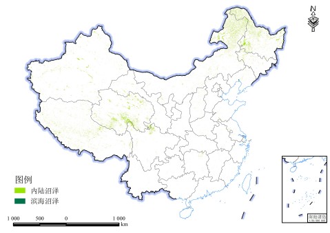
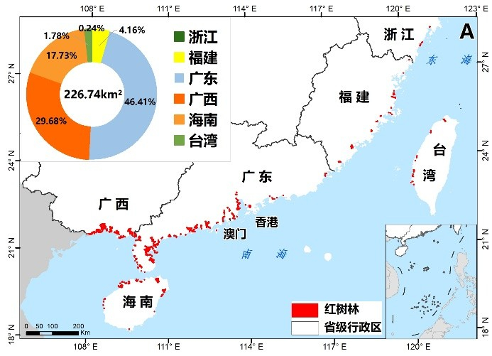
中国沼泽湿地空间分布(2015年) 中国红树林空间分布(2015年)


国互花米草空间分布(2015年) 中国滨海养殖池空间分布(2015年)
数据集由王宗明、毛德华、贾明明、任春颖等生产。在国家地球系统科学数据中心等网站注册后,即可免费下载使用。获取地址如下:(1)国家地球系统科学数据中心:http://www.geodata.cn/thematicView/wetland2020.html;(2)国家地球系统科学数据中心黑土与湿地分中心:http://northeast.geodata.cn/special/user.html#content1;(3)中国科学院东北地理与农业生态研究所科学数据中心:http://www.igadc.cn/wetlands/u54e0,http://www.igadc.cn/wetlands/u1fd8,http://www.igadc.cn/wetlands/u9647,http://www.igadc.cn/wetlands/u6c1f。
欢迎下载使用。联系人:毛德华maodehua@iga.ac.cn、贾明明jiamingming@iga.ac.cn、任春颖renchy@iga.ac.cn、王宗明zongmingwang@iga.ac.cn。
上述数据集的关联文献如下:
[1] Mao, D.H., Wang, Z.M., Du, B.J., Li, L., Tian, Y.L., Zeng, Y., Song, K.S., Jiang, M., Wang, Y.Q. 2020. National wetland mapping in China: A new product resulting from object based and hierarchical classification of Landsat 8 OLI images. ISPRS Journal of Photogrammetry and Remote Sensing, 164: 11-25.
[2] Mao, D.H., Wang, Z.M., Wu, J.G., Wu, B.F., Zeng, Y., Song, K.S., Yi, K.P., Luo, L. 2018. China's wetlands loss to urban expansion. Land Degradation and Development, 29: 2644-2657.
[3] Mao, D.H., Luo, L., Wang, Z.M., Wilson, M.C., Zeng, Y., Wu, B.F., Wu, J.G. 2018. Conversions between natural wetlands and farmland in China: A multiscale geospatial analysis. Science of the Total Environment, 634: 550-560.
[4] Mao, D.H., Liu, M.Y., Wang, Z.M., Li, L., Man, W.D., Jia, M.M., Zhang, Y.Z. 2019. Rapid Invasion of Spartina alterni?ora in the Coastal Zone of Mainland China: Spatiotemporal Patterns and Human Prevention. Sensors, 19: 2308.
[5] Jia, M.M., Wang, Z.M., Wang, C., Mao, D.H., Zhang. Y.Z. 2019. A new vegetation index to detect periodically submerged mangrove forest using single-tide Sentinel-2 imagery. Remote Sensing, 11: 2043.
[6] Jia, M.M., Wang, Z.M., Zhang, Y.Z., Mao, D.H., Wang, C. 2018. Monitoring loss and recovery of mangrove forests during 42 years: The achievements of mangrove conservation in China. International Journal of Applied Earth Observation and Geoinformation, 73: 535-545.
[7] Jia, M.M., Wang, Z.M., Li, L., Song, K.S., Ren, C.Y., Liu, B., Mao, D.H. 2014. Mapping China’s mangroves based on an object-oriented classification of Landsat imagery. Wetlands, 34: 277-283.
[8] Liu, M.Y., Mao, D.H, Wang, Z.M. 2018. Rapid invasion of Spartina alterniflora in the coastal zone of mainland China: New observations from Landsat OLI images. Remote Sensing, 10 (12): 1933.
[9] Ren, C.Y., Wang, Z.M., Zhang, Y.Z., Zhang, B., Chen, L., Xi, Y.B. 2019. Rapid expansion of coastal aquaculture ponds in China from Landsat observations during 1984–2016. International Journal of Applied Earth Observation and Geoinformation, 82: 101902.